


Storm Mike, the first named storm of the 2025/26 season, is expected to bring strong winds and heavy rain to Rochdale from tomorrow.
Today is expected to be cloudy changing to sunny intervals by late morning, with temperatures reaching 18°C. However, the Met Office has issued a number of weather warnings for wind and rain tomorrow and Saturday, with similar temperatures, but with gales and showers. Winds are expected to ease slightly on Sunday but bring patchy rain.
Met Office Deputy Chief Meteorologist Tom Crabtree said:
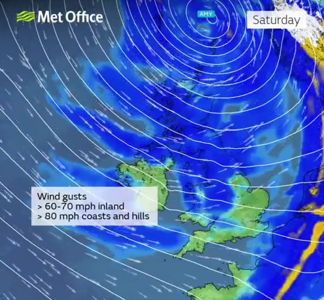
“Although there is still some uncertainty about the exact track Storm Mike will take, the system will bring gale-force winds across northern and western regions, with gusts widely reaching 50 to 60 miles per hour inland in northern Britain, and potentially reaching 70 to 80 miles per hour in places, with even stronger gusts on exposed coasts and hills, mainly in the northwest.
“Heavy rainfall is also expected, particularly over western Scotland, where totals could exceed 30–50 mm in 6–9 hours, increasing the risk of localised flooding. Forecasts and warnings will be updated as the situation becomes more clear, therefore it is important to keep an eye on the forecast for your area over the coming days.”
Met Office warnings highlight the possibility for disruption to transport, power supplies, and outdoor activities, especially from tomorrow evening into Saturday.
Storm Mike is expected to be followed by further weak frontal systems from the Atlantic next week.
The Met Office said:
“Within this we are likely to see further spells of rain or drizzle and strong winds at times, these more likely affecting northern and western areas, but all parts of the UK could see some rain from time to time.
“Through next week, there is a signal, albeit a weak one, for pressure to build in the vicinity of the UK, with a better chance of more areas seeing some longer drier interludes. On the whole temperatures look to be fairly close to average, though some chilly nights are to be expected at times.”
Storm Mike has been named in line with the Met Office’s storm naming protocol, which aims to improve public awareness and readiness for impactful weather. National Severe Weather Warnings will be issued as confidence in the track and intensity of the system increases.
The storm’s evolution is being closely monitored, with its development influenced by the remnants of Hurricanes Humberto and Imelda over the tropical Atlantic. These systems have accelerated the jet stream, contributing to the formation and intensification of Storm Mike.